Popular Posts

Showing posts with label Taming Sari. Show all posts

Thursday 5 December 2019

Mesyuarat Durbar 1897

Mesyuarat Durbar 1897 adalah merupakan mesyuarat Majlis Raja-Raja Melayu bagi Negeri-Negeri Melayu Bersekutu yang baru ditubuhkan setahun sebelumnya (1896). Ia adalah mesyuarat yang pertama diadakan di mana perkara-perkara mengenai agama, adat-istiadat dan lain-lain perkara yang berkaitan dengan orang Melayu dibincangkan. (Gambar 1).

Gambar 1: Ahli Mesyuarat Durbar 1897 di perkarangan Istana Negara, Bukit Chandan, Kuala Kangsar, Perak

Ianya dihadiri Sultan Ahmad (Pahang), Sultan Abdul Samad (Selangor), Sultan Idris (Perak) dan Tuanku Muhammad (Yang Dipertuan Besar Negeri Sembilan.  Pihak Inggeris pula diwakili Sir Charles Mitchell (Gabenor Negeri-Negeri Selat & Pesuruhjaya Tinggi Negeri-Negeri Melayu Bersekutu), Sir Frank Swettenham (Residen Jeneral Negeri-Negeri Melayu Bersekutu), Hugh Clifford (Residen Pahang), JP Rodgers (Residen Selangor), WH Treacher (Residen Perak).

Ianya telah berlangsung selama 4 hari di Istana Negara (juga dipanggil Istana Idris), Bukit Chandan, Kuala Kangsar iaitu dari 14 - 17 Julai 1897 (Gambar 2). Kenyataan tentang lokasi mesyuarat di Istana Iskandariah adalah tidak benar kerana Istana Iskandariah hanya dibina pada tahun 1933.

Gambar 2: Istana Negara, Bukit Chandan, Kuala Kangsar. Sumber: GR Lambert & Co., sekitar 1890.

Selain dari kehadiran pembesar-pembesar negeri, alat-alat kebesaran negeri juga turut dibawa bersama. Lihat hulubalang Istana yang membawa Keris Taming Sari di Gambar 3.

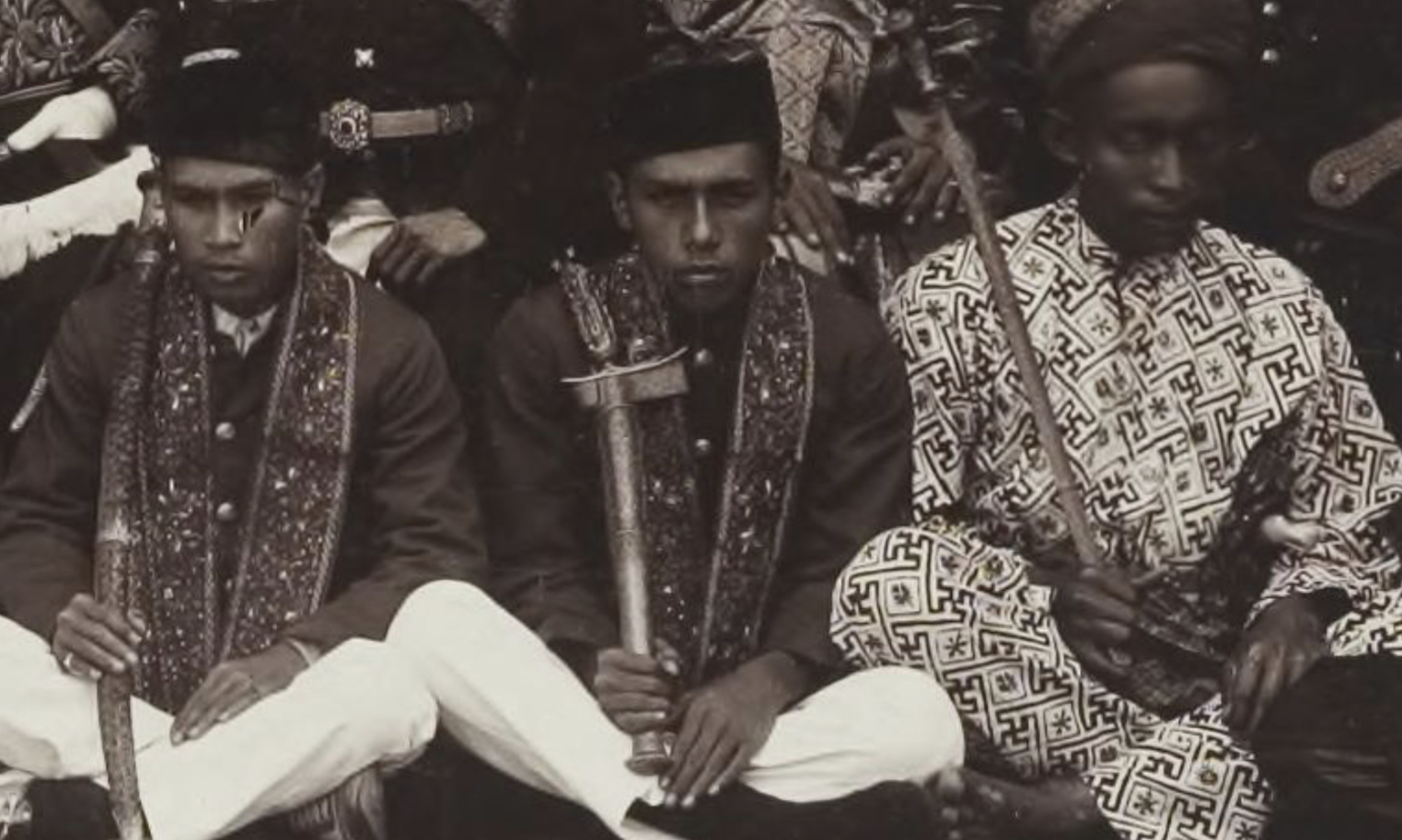
Gambar 3: Hulubalang Istana (tengah) memegang Keris Taming Sari iaitu salah satu alat kebesaran Kesultanan Perak yang diwarisi dari Kesultanan Melaka.

Secara amnya, mesyuarat Durbar 1897 ini telah meningkatkan perasaan muhibah antara ahli-ahlinya; namun ia tidak memberi kesan dari segi pentadbiran. Walaupun berlangsung selama 4 hari, mesyuarat tersebut hanya bertujuan sebagai majlis penasihat semata-mata. Perkara yang dibincangkan juga terhad dan hanya merupakan salah satu agenda dalam aturcara yang merangkumi penangkapan ikan, sukan air, teater amatur, perkelahan di kawasan air terjun, pertunjukkan bunga api dan juga bentuk hiburan lain.

Sekiranya dilihat dari segi kekerapan, jarak antara mesyuarat Durbar pertama dengan yang kedua adalah enam tahun di mana pada dasarnya Inggeris berpendirian bahawa mesyuarat sebegini tidak wajar diadakan pada setiap tahun.

Rujukan:

1. http://www.arkib.gov.my/web/guest/mesyuarat-durbar-negeri-negeri-melayu-bersekutu-yang-pertama-kuala-kangsar-julai1897
2. http://www.majlisraja-raja.gov.my/
3. https://ms.m.wikipedia.org/wiki/Majlis_Raja-Raja


Sunday 3 November 2019

Blair’s Harbour in Mersing

Before the founding of Singapore (1819), the British had actually established a harbour in an area north of Mersing in 1790. They named it ‘Blair’s Harbour’ in honour of its founder, Lieutenant Archibald Blair (1752–1815).


On 12.6.1789 a meeting of the British governor-general in Council took place in Calcutta at which Lieutenant Archibald Blair was present (See: Archibald Blair - Wikipedia). The British decided to colonize the Andaman islands in order to gain a safe harbour from which to check the activities of Malayan pirates, to serve as a refuge for shipwrecked people, a watering station, a shelter from storms for all shipping and a naval base in case of hostilities with other powers. See 18th century Malayan pirate ship:-


A survey of the Andaman Islands was initially conducted by Archibald Blair around 1788 to 1789. Port Blair of the Andaman Islands was in fact named after Archibald Blair being its founder. See Port Blair’s 1885 map:-


Around 1790, few months before the annexation of Penang, Blair found his second safe harbour to counter the threats of Malayan pirates. This second safe harbour is located at the east coast of Malaya and was named Blair's Harbour. See Plan of Blair's Harbour (published in 1793):-

Source: National Library Board, Singapore.


Blair’s Harbour is described in the said Plan as follows:-

"It is very secure being screened from both monsoons, and is easy of access the bottom a stiff clay. The water is good and may be had in abundance by making wells 5 feet deep 20 or 30 yards from high water mark.
Thereafter, “Blair’s Harbour” or “Blair Harbour” appears on British Admiralty maps and often identified as the area between the south of Keban Island or Akban (Now Pulau Aceh), Tanjung Penyabong and Teluk Sari, north of the district of Mersing, Johor. See map:-

Source: National Library Board, Singapore.

In August 1937, HMS Herald surveyed the area wherein Lt Cdr K St B Collins produced a sketch of the general view of Blair's Harbour. See his Admiralty chart titled "Selat Penyabong, View A-Malaya-East Coast-Johore". 

Source: National Archives, UK.


Since time immemorial, this area is known to sailors to provide protection from strong wind and high waves during the monsoons. There is an earlier account of the area found in the Sejarah Melayu (Sulalatus Salatin). Around 1492, when the Sultan of Pahang learned that his fiancĂ©e Tun Teja had been spirited away by Hang Nadim (according to Sejarah Melayu) or Hang Tuah (according to Hikayat Hang Tuah). See clip from the movie ‘Hang Tuah’ (1956) which is based from ‘Hikayat Hang Tuah’:


Also see clip from the movie ‘Tuah’ (1988) which is based on the story of a time travelling Hang Tuah:


According to Sejarah Melayu, about 10 of Sultan's boats gave chase, and caught up with the captors south of Pulau Keban / Akban (now Pulau Aceh). Due to the captor's archery skill, the Sultan's men were defeated and gave up the chase. Thus Tun Teja was brought to Malacca and was married to Sultan Mahmud. See Artist’s impression of Tun Teja:-


Calm seas within the natural harbour became a strategic place for Hang Nadim / Hang Tuah to launch a counter attack against the Sultan's men. According to folklore, Teluk Sari (which later became part of Blair’s Harbour) derived its name from Hang Tuah's kris 'Taming Sari'. The word 'Sari' (SAH-ree) means 'shield'. It is named "Teluk Sari" to honour the area which protected Hang Tuah from strong wind and high waves which enabled him to fend off his foe. See: Mersing - Wikipedia Bahasa Melayu, ensiklopedia bebas
See aerial view of Blair’s Harbour. Untouched by development, it probably looked the same as it did during the 1492 Battle of Keban and when the British first set foot on its shores in 1790:-


From the 'Hikayat Hang Tuah', this is the second time Hang Tuah sailed the waters of Mersing. His earlier trip was made when he was a teenager where pursued a pirate vessel into Pulau Tinggi. To this very day, the battle site still stood among old graves that by the island's folklore was the gravesite of the fallen pirates.

Folklore also has it that the clear skies between Teluk Sari and Pulau Tinggi bear witness to Tun Teja's final plea and declaration of her undying love for Hang Tuah. It is said that the skies between Teluk Sari and Pulau Tinggi remained the same to this day allowing clear view of the stars and constellations. It is currently a popular site for stargazers, astrophotographers and amateur astronomers who flocks the area from May till August each year. See photographs of the Milky-way taken above north of Mersing:

Source: Greychow.com 


Source: Greychow.com 


Credit to Milkywaychasers.com


Ekspedisi Wilkes (1838-1842)

Kapal USS Vincennes, yang memuatkan 190 anak kapal dan merupakan kapal utama Ekspedisi Wilkes. Singapura adalah destinasi terakhir yang dila...